Context
On Monday August 16, 2021 around 5.45 p.m., a fire started near the Les Sigues motorway rest area near the town of Gonfaron, on the A57 motorway.
On August 26, 2021, the firefighters officially declared “extinguished” the fire which mainly ravaged, for ten days, the national nature reserve of the plain of the Moors.
It is the biggest fire of the last 30 years in the Var (Figure 1).
 Figure 1. The Gonfaron wildfire at the departmental level.
Problem
Why did it happen there? How did it happen? Why did it last so long (10 days)? What damage did it cause?
Approach
First, I downloaded satellite images to make the before-after comparison of the study area with the hypothesis that the fire destroys the vegetation, so I will identify beforehand the vegetation which may be affected by the fire to see her disappear after the fire. So, with this method, we can only see the burned area in the forest because it is an approach via the identification of the burned area by the fact that the vegetation has disappeared and therefore we cannot see the rest (buildings, factories, parking lots, etc.)
Then, in order to answer these questions, I will use a multidimensional approach to better analyze the area.
Lately, I will quantify fire damage.
Process
Why did it happen there? Is the fact that the fire started from this specific location normal or not?
Spatial context
By analyzing the distribution of fire outbreaks by DFCI square (Figure 1), we realize that this is the first fire in history (since 1973) that started exactly from the same place (near the fire area). ‘Les Sigues motorway), however, if we take the area from where the fire started as a whole (5-10 lights), we can see that the fact that the fire started from this area is normal because the median of the distribution is equal to 6, and therefore falls into this class.
 Figure 2. Map of the distribution of fire outbreaks by DFCI tile in the area burned by the Gonfaron fire.
Weather in context
We observe that it was going to be a hot day because in the morning it was 26 ºC at 08:49. Then, at 2:49 p.m. it was 35 ºC and finally at 6:49 p.m. it was 32 ºC (Gif 1).
 Gif 1. Temperature observed in the area burned by the Gonfaron fire.
Historical context
We will see if there have been forest fires before in the area burned by the Gonfaron fire since forest fires tend to pass through areas already burned beforehand.
And this is indeed the case, the area burned by the Gonfaron fire has had at least 3 fires of more or less considerable size since the 2000s (Figure 3).
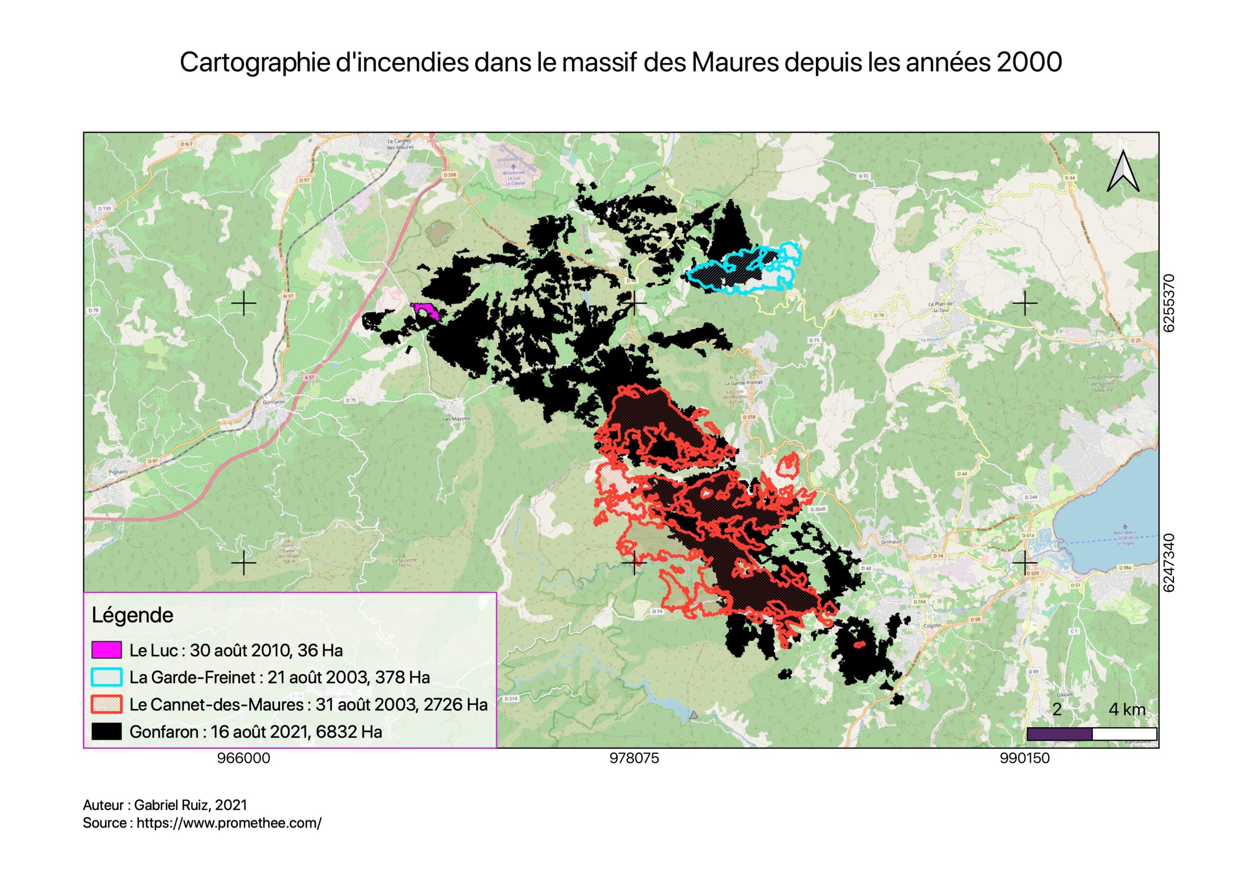 Figure 3. Mapping of fires in the Massif des Maures since 2000.
Information from Promethée:
La Garde-Freinet: August 21, 2003, 378 acres, malicious intent
Le Cannet-des-Maures: August 31, 2003, 2726 acres, malicious intent
Le Luc: August 30, 2010, 36 acres, malicious intent
Gonfaron: August 16, 2021, 6832 acres, jet of Incandescent objects
How did it happen?
Urban occupancy
According to the information I have, the fire started near the Les Sigues motorway service area near the town of Gonfaron, on the A57 motorway. We will then study this in more detail (Figure 4).

Figure 4. Map of urban occupation in the Gonfaron fire-starting area.
According to this map, the most probable fact is that the fire was started on rue Bel Amant by either a tourist or one of the residents of this area where there are 35 buildings. So the first thing to do would be to carry out an investigation in that area.
Why did it last so long (10 days)?
Land cover
By analyzing the area surrounding the fire (Figure 5), we see that the fire starting area is surrounded by sclerophyllous forest which is known for its propagating character (wooded forest). This idea is probably one of the reasons why the fire spread so much because the area has an overweight of wooded forest.
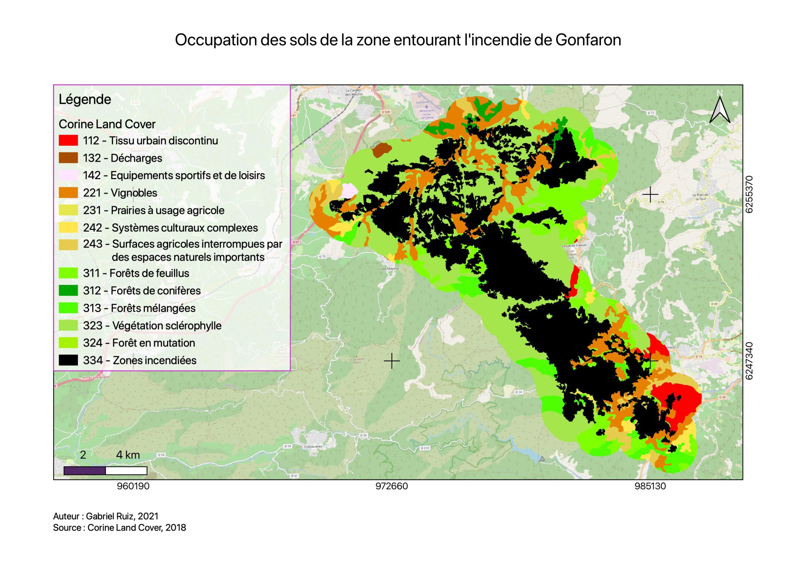 Figure 5. Map of land use in the area surrounding the Gonfaron fire.
Weather in context
The weather conditions preceding the start of the fires will play an important role in the spread of this fire.
According to the gust map (Gif 2), we have this data:
10:49 –> 32 km/h
14:49 –> 55 km/h
18:49 –> 72 km/h
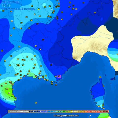 Gif 2. Wind gust values (km/h) in the area burned by the Gonfaron fire.
According to the Beaufort scale, this morning there was a good breeze, then we passed to a great chill at 2 p.m. and finally to a gale at 6 p.m.
We saw that, that day, it was getting hotter and hotter and it was also blowing more and more, which gives the perfect combination for the fire to spread. In fact, the fire starts when the wind is strong.
What damage did it cause?
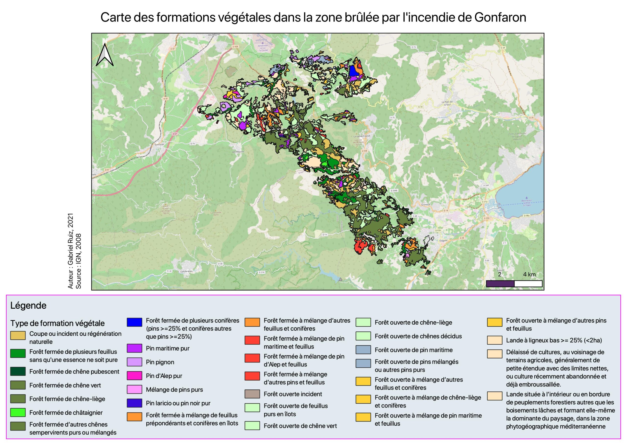 Figure 6. Map of plant formations in the area burned by the Gonfaron fire.
The most affected plant formations are:
Closed forest of several deciduous trees without a species being pure (9.9%)
Closed cork oak forest (7.5%)
After doing the previous analyses, we know that the burnt area is mostly forested, but what I have not yet said is that much of this wooded forest is National Nature Reserve (Figure 6 and 7).
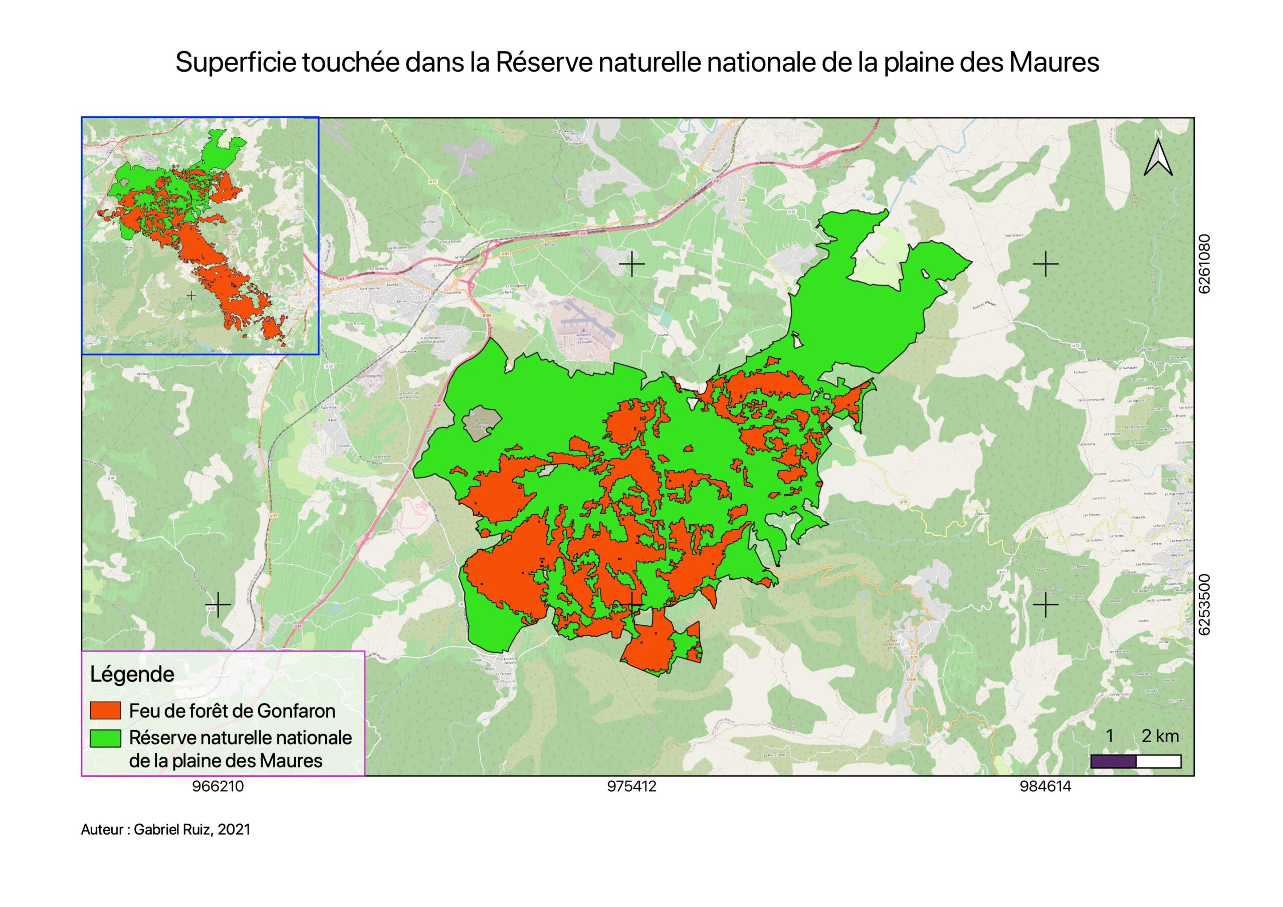 Figure 7. Plaine des Maures National Nature Reserve and the Gonfaron fire.
According to Concha Agero, the deputy director of the French Office for Biodiversity: “Half the nature reserve of the Plaine des Maures has been devastated”. We will prove this by calculating the area of the two zones, which gives:
1.68092e+07 / 5.25802e+07 = 0.32
That is 32% which is not half of the reserve, but it remains a not inconsiderable important area.
The fire also ravaged local biodiversity (Figure 8). In addition to cork oak forests, the plain of the Maures has 241 protected species, 241 protected species, including the Hermann’s tortoise, a very rare species.
 Figure 8. Map of plant formations in the Plaine des Maures National Nature Reserve.